Showing 57 items matching allendale rd
-
 Eltham District Historical Society Inc
Photograph, Liz Pidgeon, Heritage Excursion; Maroondah Aqueduct, 3 September 2016
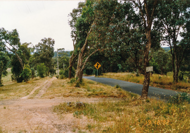
... Allendale Rd... signs acqueduct trail Allendale Rd Godber Rd Zig Zag Road ...Intersection with local Street signs Newsletter No., 229, August 2016 Heritage Excursion - Maroondah Aqueduct Walk - Saturday 3rd September The Maroondah Aqueduct was once a major link in Melbourne’s water supply system. It was built between 1886 and 1891 to transfer water from the Watts River near Healesville to the Preston Reservoir. It was 66 km in length, made up of 41 km of open channel, 10 km of tunnel through hills and 15 km of pipeline across stream valleys known as inverted siphons. The section of the aqueduct through the Eltham area has been abandoned since the 1980s but the open channel has largely been retained. A recreational path follows the aqueduct reserve. For our excursion on 3rd September we intend to walk along the section of the aqueduct adjacent to Allendale Road. This is a section not visited on previous excursions and includes the transition from open channel to the inverted siphon across the Diamond Creek valley. Apart from the aqueduct itself the main feature of the walk is the extensive views across Eltham North and Diamond Creek. Along the way we will talk about the history of the aqueduct and the area. This easy walk is about 3 km return and will take 2 to 2.5 hours. It will start at 2pm at the junction of Allendale Road with Godber Road and Zig Zag Road North, officially Diamond Creek, but on the northern boundary of Eltham. (Melway ref.12 B10). Born Digitalmaroondah aqueduct, eltham north, activities, eltham district historical society, heritage excursion, street signs, acqueduct trail, allendale rd, godber rd, zig zag road, intersection -
 Eltham District Historical Society Inc
Slide, Maroondah Aqueduct, Research, Victoria, 22 Mar. 1981
... at Allendale Rd., Eltham North. It then extends to Reservoir via St... the Diamond Creek by siphon at Allendale Rd., Eltham North ...An inspection tour of the Maroondah Aqueduct was undertaken by the Shire of Eltham Historical Society on Sunday, March 22nd, 1981, commening where the aqueduct crosses Main Rd., Research, just below Eltham College. The Maroondah Aqueduct was part of Melbourne’s water supply system. It carried water over the 66 km from the Maroondah Reservoir on the Watts River at Healesville to the Preston Reservoir. Of this length, 41 km were open channel, 10 km, tunnel through hills and 15 km in 14 inverted siphons across stream valleys. The route of the aqueduct is north of Tarrawarra and Yarra Glen, along the Yarra escarpment south of Christmas Hills and crossing Watsons Creek into the present Shire of Eltham near Henley Rd. The eastern part of the route lies entirely within the former boundaries of the shire. The aqueduct passes south of Kangaroo Ground to Research and crosses the Diamond Creek by siphon at Allendale Rd., Eltham North. It then extends to Reservoir via St. Helena, Greensborough North and Bundoora. Water first flowed through the aqueduct in February 1891 when it was fed by a diversion weir on the Watts River. Records of the building of the aqueduct indicate that it was a significant construction achievement. The present Maroondah Reservoir was completed in 1927 and the aqueduct was enlarged at that time to take increased flows. About 1971 the section of the aqueduct through and north of Research was replaced by a large pipe and that section of the channel is now unused. The channel has remained largely intact (unlike sections at Greensborough and Bundoora where long lengths of the disused aqueduct have been demolished or filled in). The M.M.B.W. relinquished control of the disused aqueduct reserve which is crown land and the Shire of Eltham took control of this section of the reserve as a linear park. The Maroondah Aqueduct is considered to be an important historic structure, not just to the local area but to the metropolitan area generally. It is considered important to preserve substantially intact long lengths of the disused aqueduct, together with its bridges and other associated structures. 35 mm colour positive transparency (1 of 5) Mount - Agfachrome Agfa CS System black 8 dotsactivities, heritage excursion, maroondah aqueduct, research (vic.), shire of eltham historical society -
 Eltham District Historical Society Inc
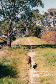
Photograph, Richard Pinn, Jah on Maroondah Aqueduct trail south of Allendale Road, c.1991, 1991c
Colour photographmaroondah aqueduct -
 Eltham District Historical Society Inc
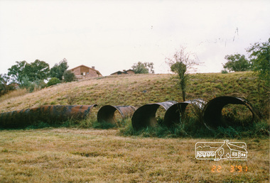
Photograph, Pipes used for original aqueduct crossing of Diamond Creek, Allendale Road, Eltham, 22 March 1991, 22/03/1991
Colour photographmaroondah aqueduct, allendale road -
 Eltham District Historical Society Inc
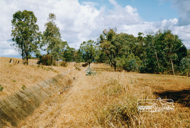
Photograph, Aqueduct path near Allendale Road, Eltham, 1991
Colour photographmaroondah aqueduct -
 Eltham District Historical Society Inc
Photograph, Old aqueduct pipes, Allendale Road, Eltham, March 1991, 1991
Colour photograph of old aqueduct pipes near Diamond Creek crossing, Allendale Road, Elthammaroondah aqueduct, allendale road, diamond creek, eltham, eltham north -
 Eltham District Historical Society Inc
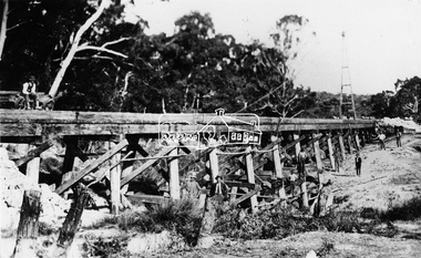
Photograph, Railway Bridge construction between Eltham and Hurstbridge, c.1912
The railway was extended from Eltham to Hurstbridge in 1912. This bridge is most likely near Allendale Road, Diamond Creek. It was one of four original trestle bridges in the stretch north of Allendale Road, which were all burnt out in January 1969 (replaced by two steel bridges and two corrugated iron culverts).This photo forms part of a collection of photographs gathered by the Shire of Eltham for their centenary project book,"Pioneers and Painters: 100 years of the Shire of Eltham" by Alan Marshall (1971). The collection of over 500 images is held in partnership between Eltham District Historical Society and Yarra Plenty Regional Library (Eltham Library) and is now formally known as the 'The Shire of Eltham Pioneers Photograph Collection.' It is significant in being the first community sourced collection representing the places and people of the Shire's first one hundred years.Digital image One 4 x 5 inch B&W negative One 9 x 12.5 cm printshire of eltham pioneers photograph collection, hurstbridge, allendale road, hurstbridge railway extension, railway bridge, railway line construction, trestle bridge, diamond creek (creek) -
 Eltham District Historical Society Inc
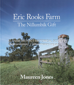
Book, Maureen Jones, Eric Rooks Farm: the Nillumbik gift, 2022
History of the Rooks family and farm, located at 167 Allendale Road, Diamond Creek. The property was first settled in 1865 and held by four generations of the family always retaining its rural landscape. Family archives and historical newspaper reports supplemented with photographs from the collection of Nillumbik Historical Society have contributed to the telling of this family history and history of the property. Hailing from Cambridgeshire England, the Diamond Creek pioneer settler was Isaac Rooks. He, his brothers and descendants are all profiled. The story of the Maroondah Aqueduct which passed through the property is also discussed including the recent development of the Aqueduct trail. More recently managed by Eric Rooks whose story is also represented, Eric donated the property to the National Trust upon his death in 2020 with the condition that a Reserve would be established.93 pagesnon-fictionHistory of the Rooks family and farm, located at 167 Allendale Road, Diamond Creek. The property was first settled in 1865 and held by four generations of the family always retaining its rural landscape. Family archives and historical newspaper reports supplemented with photographs from the collection of Nillumbik Historical Society have contributed to the telling of this family history and history of the property. Hailing from Cambridgeshire England, the Diamond Creek pioneer settler was Isaac Rooks. He, his brothers and descendants are all profiled. The story of the Maroondah Aqueduct which passed through the property is also discussed including the recent development of the Aqueduct trail. More recently managed by Eric Rooks whose story is also represented, Eric donated the property to the National Trust upon his death in 2020 with the condition that a Reserve would be established.diamond creek, rooks family, isaac rooks, maroondah aqueduct, maroondah aqueduct trail -
 Eltham District Historical Society Inc
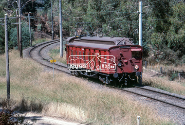
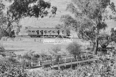
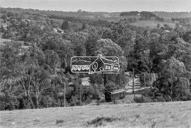
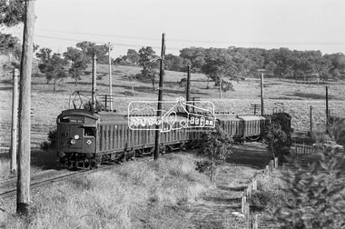
Photograph, Single Motor Carriage 471M (Red Rattler) Tait train heading to Hurstbridge just before crossing over the Diamond Creek north of Allendale Road, January 1983, 1983
Digital TIFF file Scan of 35mm Kodachrome colour positive transparency in cardboard slide mount.Processing date Feb 1983allendale road, diamond creek, george coop collection, hurstbridge line, red rattler, red rattler single carriage, single carriage train, single motor carriage, tait train -
 Eltham District Historical Society Inc
Book, Diamond Creek Basin Study. Part 1, A Compendium of Factors Relevant to Stormwater Flows, 1980
Basin Studies are studies to evaluate water supply and demand and help ensure reliable water supplies by identifying strategies to address imbalances in water supply and demand.Spiral Bound. 157 leaves in various foliations (some folded) : illustrated. (some colour.), maps (some colour.)aerial photographs, allendale road, arthurs creek mine, arthurs creek road bridge, arthurs creek, bald spur look-out, bank protection, bolton steet, bridge street bridge, bridge street, bridges, challenger street, chute street, construction, coolaroo drive, culvert, deep creek, diamond creek basin, diamond creek region, diamond creek, diamond street bridge, drainage works, eltham lower park, eltham town park, eltham trestle bridge, eltham west drains, eltham, erosion, flood management, floods, footbridge, glen katherine estate, gold mining, gum glade, hurstbridge, kangaroo ground, kinglake escarpment, kinglake national park, latiners hat factory, main road bridge, main road, masons falls, melbourne metropolitan board of works, monash bridge, mount sugarloaf, nillumbik park, orchards, railway culvert, railway line, ramptons road, real estate advertisement, research creek, st helena east drain, st helena road, st helena, storm sewers, stormwater, sugarloaf-preston transfer main crossing, susan street, union mine, village pond, water flow, watkins street, wattletree road, weidlich road, wingrove park, yarra river, zig zag road, water supply, basin study -
 Eltham District Historical Society Inc
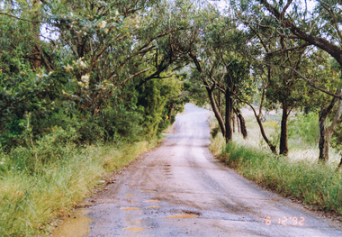
Photograph, Ingrams Road at Allendale Road, 6 December 1992, 06/12/1992
The Eltham Horse Trail: Research and Warrandyte to Kinglake: Survey of proposed route, December 1992: (1) Research to Kangaroo GroundColour photographallendale road, eltham horse trail (1992 survey), ingrams road -
 Eltham District Historical Society Inc
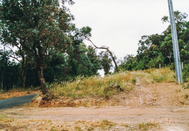
Photograph, Ingrams Road, south from Allendale Road, Research, 19 December 1992, 19/12/1992
The Eltham Horse Trail: Research and Warrandyte to Kinglake: Survey of proposed route, December 1992: (4) Connecting trail to ElthamColour photographeltham horse trail (1992 survey), allendale road, ingrams road, research (vic.) -
 Eltham District Historical Society Inc
Photograph, Ingrams Road looking north to Allendale Road, Research, 19 December 1992, 19/12/1992
The Eltham Horse Trail: Research and Warrandyte to Kinglake: Survey of proposed route, December 1992: (4) Connecting trail to ElthamColour photographeltham horse trail (1992 survey), allendale road, ingrams road, research (vic.) -
 Eltham District Historical Society Inc
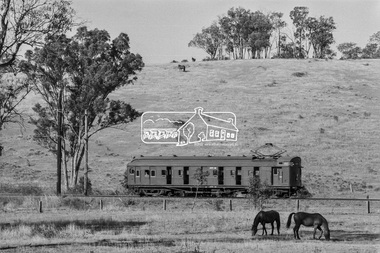
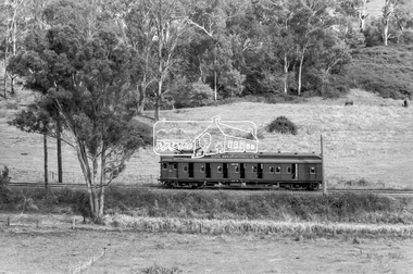
Photograph, George Coop, Single Motor Carriage 471M Tait (Red Rattler) train near Allendale Road level crossing, Eltham, March 1980, 1980
Digital TIFF file Scan of 35mm Kodak Safety 5063 black and white transparency471m, allendale road, eltham, hurstbridge line, level crossing, red rattler, single motor carriage, tait train -
 Eltham District Historical Society Inc
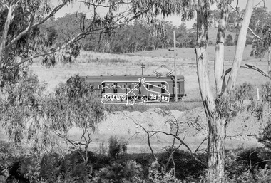
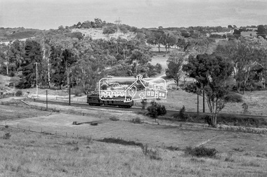
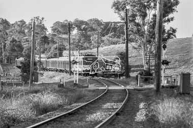
Photograph, George Coop, Hurstbridge bound Single Motor Carriage 471M Tait (Red Rattler) train near the level crossing at Allendale Road, Eltham, March 1980, 1980
Digital TIFF file Scan of 35mm Kodak Safety 5063 black and white transparency471m, allendale road, hurstbridge line, level crossing, red rattler, single motor carriage, tait train -
 Eltham District Historical Society Inc
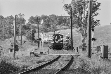
Photograph, George Coop, Eltham bound Single Motor Carriage 471M Tait (Red Rattler) train from Hurstbridge approaches the level crossing at Allendale Road, Eltham, March 1980, 1980
Digital TIFF file Scan of 35mm Kodak Safety 5063 black and white transparency471m, allendale road, hurstbridge line, level crossing, red rattler, single motor carriage, tait train -
 Eltham District Historical Society Inc
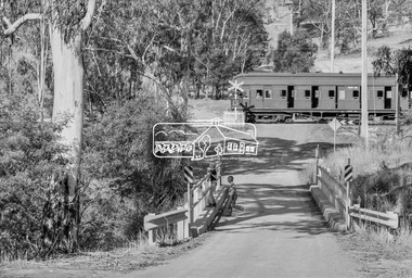
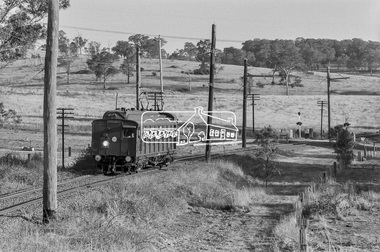
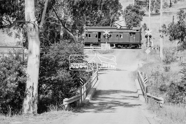
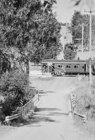
Photograph, George Coop, Single Motor Carriage 471M Tait (Red Rattler) train crossing Allendale Road, heading to Eltham station, 6 December 1980, 1980
The single carriage Tait regularly ran between Eltham and Hurstbridge stations. Looking east along Allendale Road, Eltham to the railway level crossing. The tree on the left remains today (2019) https://goo.gl/maps/zngEcUA29tEWFzuj7Digital TIFF file Scan of 35mm Ilford FP4 black and white transparency471m, allendale road, eltham, hurstbridge line, railway level crossing, red rattler, single motor carriage, tait train -
 Eltham District Historical Society Inc
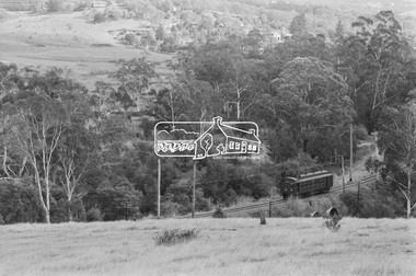
Photograph, George Coop, A Tait (Red Rattler) train passes through the level crossing at Allendale Road, Eltham bound for Princes Bridge, c.1981, 1981
Digital TIFF file Scan of 35mm Ilford FP4 black and white transparencyallendale road, level crossing, red rattler, tait train -
 Eltham District Historical Society Inc
Photograph, George Coop, A Princes Bridge bound Tait (Red Rattler) train heading towards Eltham approaches the level crossing at Allendale Road, Eltham, c.1981, 1981
Digital TIFF file Scan of 35mm Ilford FP4 black and white transparencyallendale road, level crossing, red rattler, tait train